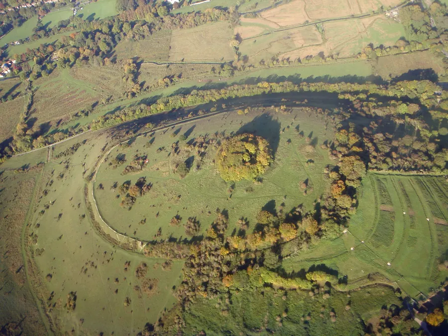
St Catherine’s Hill rises above the Itchen valley two kilometres south of Winchester — a 43-hectare chalk downland hill and a Site of Special Scientific Interest.
It is owned by Winchester College and managed with the Hampshire and Isle of Wight Wildlife Trust, and it is open to the public and free.
The summit carries an Iron Age hillfort, built in about the third century BC — a single rampart and ditch enclosing roughly 9 hectares, with an entrance on the north-eastern side.
It was occupied for two or three centuries and then abandoned, probably when the population moved to the larger settlement at Oram’s Arbour, which in turn became Roman Venta Belgarum and then Winchester.
So the hill is, in effect, Winchester’s predecessor: the place people lived before there was a city in the valley below.
On the summit inside the ramparts stood a medieval chapel of St Catherine, demolished at the Reformation; its foundations were excavated and the site is marked by a clump of beech trees visible for miles.
Cut into the turf near the summit is a maze — a mizmaze, one of only eight surviving turf mazes in England.
It is a square labyrinth of shallow trenches, and its origin is unknown. The earliest reference is from the eighteenth century, and tradition attributes it to a Winchester College schoolboy kept back over a holiday, though this is undocumented. Others argue it is considerably older and connected with the chapel.
Whatever its origin, walking it is free, quiet and oddly absorbing. Please stay on the path — the trenches erode easily.
The reason for the SSSI is chalk grassland, one of the richest and rarest habitats in Britain.
Orchids — several species — round-headed rampion, and a strong butterfly list including chalkhill blue, adonis blue and marbled white in June and July.
The grassland is grazed to maintain it. Cattle may be on the hill.
From the free car park at Garnier Road, at the foot of the hill.
There are two routes up: the steps — the direct and hard route, which is a genuine climb — and a longer, gentler path round the flank. Visitors who take the steps describe them with feeling.
At the top: the view. Winchester spread below with the cathedral at its centre, the Itchen valley, the water meadows, the Hospital of St Cross to the south, and the South Downs beyond.
The Itchen runs along the foot of the hill with a towpath, and the water meadow walk to St Cross — the oldest almshouse in England, founded in 1132, where you can still ask for the Wayfarer’s Dole, a horn of ale and a piece of bread given to any traveller who requests it — is one of the finest short walks in England.
Free, open at all times.
Parking: a small free car park at Garnier Road, which fills.
Facilities: a small café on the bridge above the car park, with a bike repair kit available.
Time: an hour for the hill; half a day with the St Cross walk.
Access: the hill is steep with steps and rough grass; not accessible. The riverside path below is level.
Underfoot: chalk grassland, slippery when wet.
Dogs: welcome, under control near livestock.
Yes, free and open at all times, with free parking at Garnier Road.
The steps are steep and hard work. There is a longer, gentler route round the flank.
A turf maze near the summit, one of only eight surviving in England, of unknown origin. Stay on the path — the trenches erode.
Winchester and its cathedral in the valley below, the Itchen, the water meadows and the South Downs beyond — the best view of the city there is.
The water meadows south along the Itchen to the Hospital of St Cross, the oldest almshouse in England.