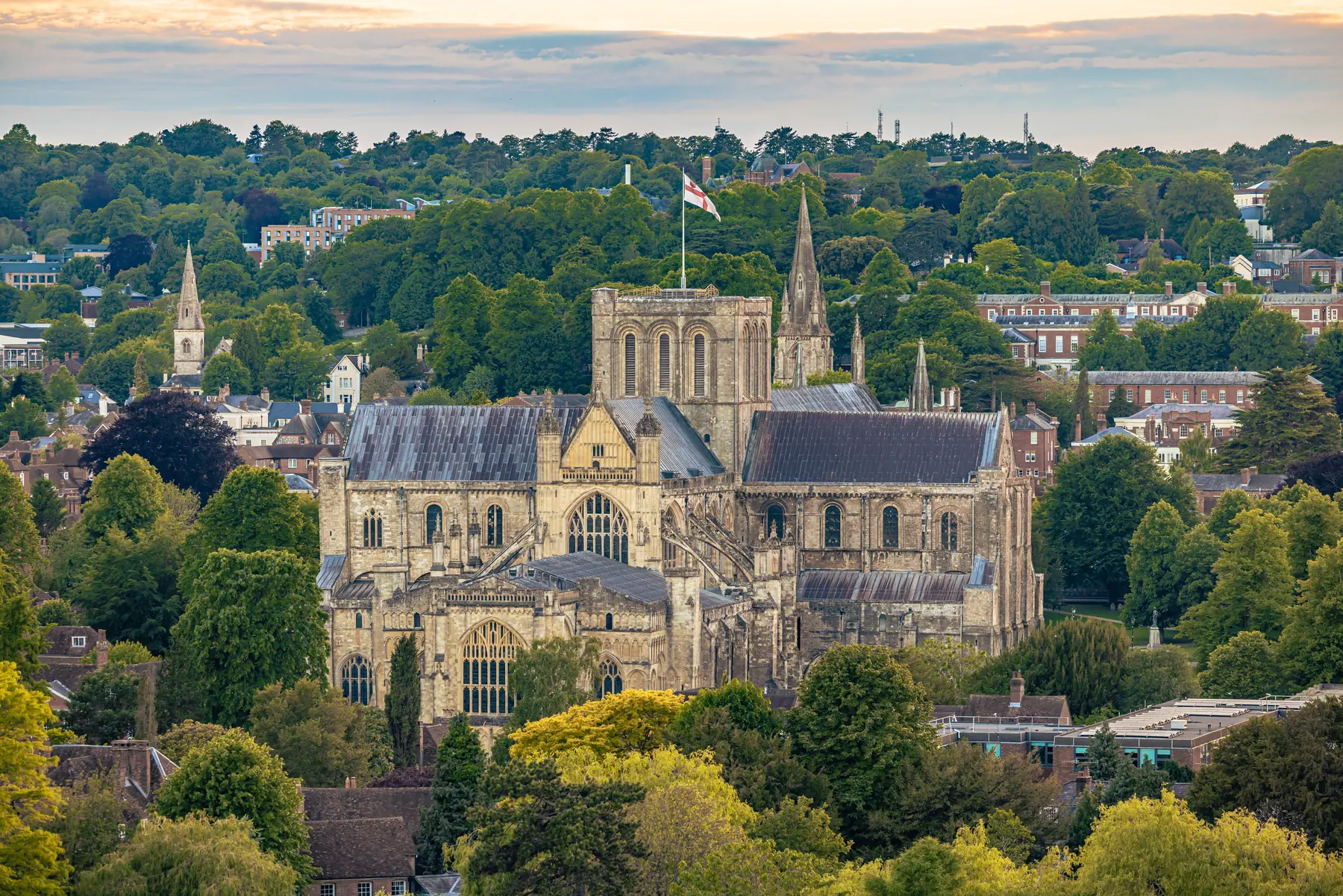
St Giles Hill is the viewpoint immediately east of the Broadway, and it is the photograph everyone takes of Winchester. Ten to twenty minutes from King Alfred’s statue, a public park on a chalk spur, the cathedral laid out below you with the college, the Close and the roofs of the castle hall beyond. Free, always open, and over before you have decided whether to go.
It is not St Catherine’s Hill. That is the Iron Age fort two kilometres south-east, with a mizmaze on the summit and a steep flight of steps from the water meadows. Different hill, different walk, different afternoon. The walks guide covers both. This page is the city one.
Winchester sits in a chalk valley with a hill on each side of the Itchen. St Catherine’s is the down to the south, a Site of Special Scientific Interest owned by Winchester College. St Giles is the spur to the east, a municipal park above Chesil Street, with houses on the upper slope and a viewpoint looking straight down onto the cathedral.
People confuse them because both are called a hill and both have a view of the same building. The test is distance. If you are still looking at the Alfred statue five minutes ago, you are on St Giles. If you have walked the meadows toward St Cross, you are on the other one. St Giles is the five-minute view. St Catherine’s is the forty-five-minute climb. You can do both in a day; do not treat them as the same slot after lunch.
From the main viewpoint the city reads as a plan. The cathedral is the long roof in the middle, nave running west, the Close around it, Kingsgate at the far corner. Winchester College and Wolvesey Castle sit along the east walls, which is why the ruined palace is in the same view as the west front. The High Street is a straight Saxon line from the Westgate down to Alfred. The Great Hall is the roof at the top of that line, all that is left of the castle Cromwell had destroyed.
The Itchen is the silver thread along the near edge, with the mill and City Bridge at the bottom of the hill you have just climbed. On a clear day the downs close the horizon. On a murky one you still get the cathedral, which is the point.
Early morning and the last hour before sunset are the best light on St Giles, because the view faces west. The view faces west, so evening is when the stone picks up colour. In the school holidays at eleven it is a bench with a queue for the rail. The honest picture includes the cathedral.
The hill is named for the fair, not the other way round.
Medieval St Giles Fair was held on this hillside, one of the great fairs of England, granted to the Bishop of Winchester and running for days around the saint’s feast in early September. Traders came from across the country and from the Continent; the suburb on the slope was a temporary town. It declined after the fourteenth century, as fairs did, and the hill became what it is now: a park, a view, a name on the map.
You will not find stalls. You will find a municipal green with a history under it. The Broadway at the foot still behaves like a fairground on Hat Fair weekend in July, but that is a different festival on different ground. Check Visit Winchester if a street-theatre weekend is why you are in town.
On foot from the statue. Cross City Bridge by the mill, then climb. The direct way is the stepped path up the face of the hill — a short, honest pull, ten to fifteen minutes from the Broadway if you do not dawdle. The kinder way works round toward Magdalen Hill and Alresford Road, coming in at the top of the park without the steepest steps. Both are signed once you are on the east bank. If you find yourself on a ring road, you have missed the path; turn back toward the river.
Time: ten to twenty minutes from the Broadway, depending on the route and the knees. The round trip from Alfred, including time at the rail, is under an hour.
By bus or car to the top. Alresford Road runs along the ridge. There is no dedicated viewpoint car park worth circling for. Chesil Street Multi Storey, at the foot of the hill on Barfield Close, is the correct park — 616 spaces, then the steps. Park and ride to the Broadway and walk is the other clean arrival. Do not leave the car on the residential streets of the hillside. See parking in Winchester.
The mill at the bottom has no parking. Combine it with the hill; do not add a hunt for a mill bay.
The top is a public park: grass, trees, a circuit, the viewpoint, and enough bench to sit. It is not a country hill. Dogs, buggies and a slow relative are all normal here, in a way they are not on the steps of St Catherine’s.
There is a short accessible circuit on the upper ground, once you have arrived by the Alresford Road side or by the gentler path. The steps from the river are the other product: a climb, a view, a descent. People with wheels, or who would rather not do a flight of chalk steps, should use the ridge and the circuit and skip the face. The view is at the top, not halfway up the steps.
Surfaces are park path and grass, slick after rain. There is no café on the summit. The city is ten minutes down; the mill café sits at the bottom if it is open — check the National Trust page, because hours have been around 10–16 while the water wheel is replaced. Stay on the paths where the slope drops.
This is the shot on the front of the guide. The cathedral from St Giles Hill is how Winchester is pictured, and the reason a licensed camera sits on this slope rather than in the nave.
Sunset is the hour, because the view faces the west front. In June and July you can walk up after dinner and still have light. In October you want to be on the hill before the shops shut, or you will be coming down the steps in the dark. There is no lighting on the face of the hill that you should count on.
Dawn is quieter and often clearer. A cold bright winter morning from this park is the best the city looks, and you will have the rail. An August Saturday at noon is the worst: haze, shoulders, and a photograph of other people’s phones.
The Itchen piece is the water; this hill is the stand from which you see how the water and the city fit. Do not fly a drone over a park full of people eating sandwiches. The view is already there.
Do it on arrival, from the Broadway, before the Close has filled. Do it at the end, when the stone is in evening light. Do not save it for “if we have time” — it is twenty minutes, and it is the view the rest of the day is trying to live up to.
A circuit that works: Alfred, City Bridge, the mill if it is open, up the steps, ten minutes at the rail, down the gentler path, Abbey Gardens for a bench, then the cathedral or the High Street. Reverse it if you would rather climb after lunch.
It pairs with Wolvesey and the Weirs, because those roofs are in the view and then under your feet. It does not pair well with St Catherine’s in the same hour. One hill, then the city; the other hill is a different afternoon, with the meadows attached.
Our free things guide lists the hill as the quick view, which is accurate. The Alfred and Round Table piece is the history under the roofs you are looking at.
Free. Open at all times because it is a public park, not a visitor centre. There is no one to close it.
How long. Twenty minutes up and down if you are brisk; forty-five with a sit. It is not a morning.
Underfoot. Steps on the face, park path on the top. Trainers will do in the dry. After rain the chalk steps are the same warning as St Catherine’s, in miniature. Buggies and wheels should use Alresford Road and the upper circuit.
Toilets and coffee. In the city, not on the hill. Do not skip it because it looks small on the map, and do not confuse it with St Catherine’s.
St Giles Hill is free, close, and out of proportion to the effort. Walk up from Alfred, give the cathedral the view it was built to occupy, and the rest of the city will sit in the right place.